Project
PPS Artificial Intelligence for recognizing megafauna (seabirds and mammals) in and around offshore wind farms (AI-MEG)
The North Sea is becoming more and more crowded and especially wind farms at sea are taking up an increasing area. Protected species, such as marine mammals and birds, most likely avoid offshore wind farms and this loss of habitat can result in declining populations. However, it is also possible that the animals get used to wind turbines in their habitat. It is important for the further rollout of offshore wind farms to have a clear picture of the distribution of marine mammals and birds at the level of individual species, both inside and outside wind farms. The current method of observation, using visual observers in aircrafts, has become unworkable. Due to the height of the wind turbines, these surveys have to be flown at too high an altitude for human observers. A new technique, using high-definition cameras, offers a solution: these cameras can fly at a higher altitude and the images obtained can be stored for future analyses. At the moment, however, the assessment of the collected images is still human work, very labour-intensive and therefore expensive. There is thus an urgent need to automate this part of the process. With the emergence of Deep Learning within Artificial Intelligence (AI), it is possible to perform image recognition automatically.
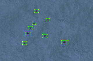
We are developing Deep Learning models capable of detecting, identifying and counting species on the stream of images, focusing on seabirds, but also other fauna where possible. This development requires the development of software that is fed with images previously analysed by experts for species detection and identification. For this purpose, images collected from two wind farms in the North Sea are used: Gemini Windparm, north of the island Schiermonnikoog, and Borssele Wind Farm, west of Rotterdam. These images are visually analysed ("annotated") by experts from BioConsult SH in Germany. The joint dataset, with images from Gemini and Borssele, is so extensive that sufficient annotated images will be obtained to feed the software, even for the slightly less numerous species.
In addition, the situation from the air will be compared with the situation on the ground by having an experienced bird observer count birds at Gemini Wind Farm during one or more flights. This will make it possible to compare the type of birds detected on the images with what is seen in a corresponding location “on the ground”.
If the models perform sufficiently accurately (compared to the accuracy of the human expert), they will be integrated into a software platform yet to be set up, which will allow video-surveys to be analysed (semi-)automatically when the software is available to the user. Ultimately, this platform will be publicly accessible for image recognition analyses and reports.
Part of this project is also an advisory committee, consisting of bird and AI experts and policy makers, who can give feedback on the AI and platform development based using the Agile work approach.
The research question Gemini Windpark is interested in, is to what extent certain species of birds avoid the wind farm. The extent of this habitat loss will be determined by comparing the densities within the wind farm with those in the area surrounding the wind farm, based on the collected images. The area surveyed for this purpose is therefore considerably larger than Gemini Windparm itself. The images obtained by the Gemini and Borssele projects, as well as the software developed, will contribute to the further development of the (inter)national infrastructure of image recognition at sea, both in the Netherlands and abroad.
The AI-MEG project aims to:
1. To determine the habitat loss of Razorbills and Guillemots at Gemini Windfarm;
2. To develop species identification in the obtained images (annotations) of Razorbills and Guillemots by ground truthing during flights;
3. Development of Deep Learning (AI) models to automatically detect, identify and count seabirds and marine mammals in the digital images.
4. Integration of the Deep Learning models in a (software) platform with which relevant digital image surveys can be carried out (semi-)automatically (when the AI model performs adequately).
Interchange of knowledge
This research contributes explicitly to a larger parallel project led by Rijkswaterstaat (RWS), in which work is being done on setting up a national digital aircraft survey AI and data structure (see this roadmap). The goal of the RWS project is to be able to process and analyse all digital aircraft surveys conducted in the Netherlands (and eventually throughout the North Sea) in a publicly accessible platform. Within the RWS programme Wozep, a pilot has already started with image collection inside and outside the Borssele wind area, the images of which will also be made available to this project.